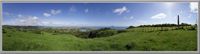
View of Whakatane township and river with the Rangitaiki plains in the distance, as seen from Kohi Point lookout (elevation 183 m) to the east of Whakatane. The island is Moutohora, or Whale Island, and is volcanic in origin.
The Bay of Plenty region is characterised by a diverse physical geography. Volcanic landscapes of high plateaus, cones and lakes dominate the area around Rotorua and further south. To the east, steep forested terrain defines the topography of Te Urewera National Park and adjacent Ruakumara Ranges. In contrast, coastal lowlands and floodplains extend from Waihi Beach in the west to Opotiki in the east. The major rivers of the region include the Tarawera, Rangitaiki and Whakatane Rivers that flow north across the Rangitaiki Plains, and the Waioeka River that enters the coast at Opotiki. All of these rivers represent a natural hazard to the people of the Bay because several major urban centres have been built alongside them, meaning that flooding is a recurrent hazard.
Exotic pine plantations now cover large parts of the volcanic plateau, and the coastal strip supports a large dairy industry, alongside extensive kiwifruit and citrus orchards. Volcanic resources are continually being utilised by both tourism and a growing geo-thermal industry. The Port of Tauranga provides a means to export much of the region's produce, while the seas of the Bay of Plenty support important commercial and recreational fisheries.
Please refer to the interactive map for more detail on the geography of the Bay of Plenty.