Undertaking hazard assessments is important, as the information gained is used to construct a hazard management plan. When assessing hazards we must consider the nature of the event, in particular:
We have already seen the effects of the debris flows, debris avalanches, and debris floods and determined extent of damage. Now we need to investigate the frequency of the event. To do this we need to look for evidence of past events.
There is both historical and geological evidence of previous debris flows at Matata.

28 floods have been recorded in the eastern Bay of Plenty in the last 137 years; some of those affected Matata - and at least 5 were debris flows:
| 1. | In 1869 - destroyed a flour mill, |
| 2. | In 1906 - eyewitness accounts "huge boulders being rolled along ... the ground shaking ... the sound like thunder", |
| 3. | In 1939 - a home shifted off its foundations, |
| 4. | In 1950 - huge boulders swept into Matata, |
| 5. | In 2005 - widespread destruction. |
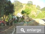
Huge boulders have been used as landscaping features (most likely from the 1950 event). Boulders this size can only be moved by debris flows and their presence provides clear evidence of previous events.
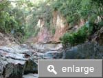
In the steep catchments behind Matata the stream valleys are manifest as deeply incised u-shaped canyons that have cut through the mantling Matahina Formation and into the underlying Ohope Formation. The distinctive u-shaped channels are a feature of repeated debris flows over a long time.
The most compelling evidence comes from the presence of boulders underground that were unearthed during excavation of foundations, and others seen 1.6km offshore by divers. This demonstrates that debris flows have been responsible for building up the land on which Matata sits.